↓
 

Gulf Shores Land Surveying

Local Land Surveyors in Gulf Shores, AL

Gulf Shores Land Surveying
  • Home
  • ALTA Survey
  • Boundary Surveying
  • Construction Survey
  • Drone LiDAR Mapping
  • Elevation Certificate
  • Land Surveying
  • Topographic Survey
  • Blog
  • Contact Us
Home - Page 2 << 1 2 3 4 … 7 8 >>

Post navigation

← Older posts
Newer posts →

Before You Build, You Need a Topographic Survey. Here’s Why.

Gulf Shores Land Surveying Posted on May 29, 2026 by GulfShoresSurveyorMay 25, 2026
Surveyor reviewing a topographic survey with contour lines and land elevation data before site development

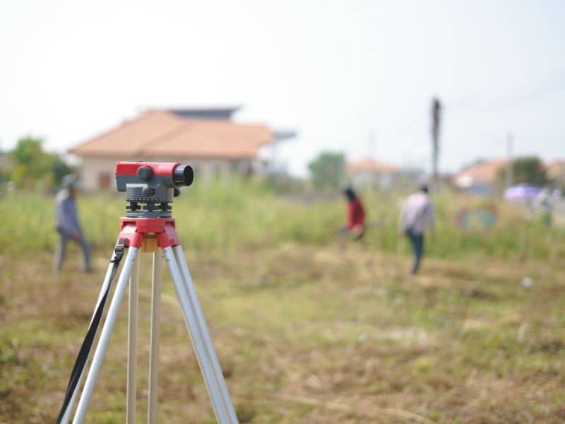
A topographic survey maps the physical shape of a piece of land, showing elevation changes, slopes, trees, drainage features, and existing structures. It does not establish who owns the property. Architects, engineers, and builders use it to design projects that work with the natural lay of the land instead of against it.

The Survey That Reads the Land

Most people think of land surveying as something that establishes property lines. That is true for some survey types, but a topographic survey does something different. Instead of asking “where does my property end,” it asks “what does this land actually look like?”

This distinction matters. You can own a piece of land and still have no idea how it drains after a storm, where the high and low spots are, or whether a proposed building will sit on stable ground. A topographic survey answers all of those questions before any design work begins.

What a Topographic Survey Captures

When a surveyor completes a topographic survey, the final map shows two categories of information.

Natural features:

  • Ground elevation across the entire site
  • Slopes, ridges, and low spots
  • Trees and significant vegetation
  • Streams, ponds, wetlands, and drainage paths

Man-made features:

  • Existing buildings and structures
  • Driveways, roads, and walkways
  • Retaining walls and fences
  • Visible utility lines and drainage structures

All of this information is combined into a single map that your designer, engineer, or architect can work from directly.

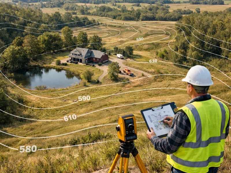
How to Read a Topographic Map: Contour Lines Explained

Topographic map with contour lines used for site planning and construction design

The most important feature of any topographic map is the contour lines. These are curved lines that connect points on the land that share the same elevation. Once you understand what they mean, reading a topo map becomes much easier.

Here is the simple version:

  • Lines that are far apart mean the ground slopes gently. The land is relatively flat between those two elevations.
  • Lines that are close together mean the ground drops or rises steeply. A cluster of tight lines indicates a hill or a sharp drop-off.
  • Circular lines typically indicate a hill or a depression, depending on the numbers shown.

Every contour line on the map is labeled with an elevation number. If one line reads 20 feet and the next reads 22 feet, the ground rises two feet between those two points. That kind of detail is exactly what a drainage engineer or foundation designer needs before work begins.

You do not need to be able to read the map yourself. Your surveyor, architect, or engineer will interpret it. But understanding the basics helps you ask better questions and follow along when your project team reviews the results.

When Do You Actually Need a Topographic Survey?

A topographic survey is not required for every project. However, skipping it when you do need one is a costly mistake. Here are the situations where one is either required or strongly recommended.

You Are Designing a New Home or Addition

Any architect designing a custom home needs accurate elevation data to make good decisions. The slope of the land affects where the home sits, how the foundation is designed, where water will flow away from the structure, and whether the driveway will work at a safe grade. Without a topo survey, these decisions are based on guesses.

You Need a Permit for Site Work

Many municipalities require a topographic survey as part of a grading or drainage permit application, especially for projects that affect how water flows across a property. In many cases, documented elevation data is required before a permit can be approved.

Your Property Has Drainage Problems

If your yard floods after heavy rain, or if water pools near your foundation, a topographic survey can identify exactly why. It shows where the land is channeling water and whether the existing drainage paths are working. That information is the starting point for any drainage correction plan.

Your Land Is Near a Floodplain or Waterway

Properties near rivers, creeks, bays, or wetlands often have complex elevation changes that affect both design and flood risk. A topographic survey provides the precise elevation data needed to evaluate flood exposure, satisfy FEMA requirements, and design responsibly in sensitive areas.

You Are Planning a Pool, Retaining Wall, or Major Landscaping Project

These projects change the way water moves across a site. A pool changes to an impervious cover. A retaining wall redirects runoff. Without knowing how the land sits before construction begins, these projects can create drainage problems that did not exist before.

What You Receive at the End

A completed topographic survey is typically delivered as a digital CAD file and a printed map. The map shows your property with all natural and man-made features plotted to scale, along with contour lines at a set interval.

Your design team uses this file directly. Architects load it into their design software. Civil engineers use it to calculate drainage volumes and design grading plans. Permit offices use it to verify that proposed site work meets local code.

Keep a copy of your topographic survey on file. If you make future improvements to the property, having the original topo as a baseline makes the next round of design work faster and cheaper.

What Happens If You Skip It?

Some property owners skip the topographic survey to save money upfront. This often costs more in the long run.

Without accurate elevation data, designers make assumptions. Those assumptions can lead to foundations that need to be re-engineered, drainage problems discovered mid-construction, permit rejections that delay your project, or grading work that moves water toward your home instead of away from it.

A topographic survey is not the most expensive part of any building project. Fixing design mistakes that result from skipping one almost always is.

Frequently Asked Questions

Is a topographic survey the same as a boundary survey? 

No. A boundary survey establishes legal property lines and sets corner markers. A topographic survey maps the physical shape of the land, including elevation and features. They are often ordered together for new construction projects, but they serve different purposes.

Does a topographic survey show property lines? 

A topographic survey may show the general outline of a property, but it is not a legal boundary document. If you need your property lines established or certified, a separate boundary survey is required.

How long does a topographic survey take? 

Field work for a standard residential lot typically takes one day. Processing the data and delivering the final map usually takes an additional three to seven business days, depending on the firm’s workload.

Do I need a topographic survey if my land is flat? 

Possibly. Even flat land has subtle elevation changes that affect drainage. Many permit offices require elevation documentation regardless of terrain type, especially in coastal and flood-prone areas.

Posted in land surveying | Tagged topographic survey

What to Expect During a Land Survey: A Step-by-Step Guide

Gulf Shores Land Surveying Posted on May 27, 2026 by GulfShoresSurveyorMay 25, 2026
Survey crew working on a residential property while survey equipment is set up during a land survey

A land survey has three main phases: research and preparation, fieldwork on your property, and office work to produce your final document. From start to finish, most surveys take one to three weeks. You do not need to be present during the site visit, but there are a few simple things you can do ahead of time to help the process go smoothly.

You Booked a Survey. Now what?

Getting a land survey is one of the smartest things a property owner can do. But if you have never been through the process before, it can feel like a mystery. What does the surveyor actually do on your property? Do you need to be home? When will you get your results?

Phase 1: Research and Preparation (Before the Surveyor Visits)

Before a surveyor ever sets foot on your property, they spend significant time in the office doing research. They review your deed, prior survey records, county plat maps, and any other legal documents related to your land. This research phase can take several days and directly affects the accuracy of the final survey.

Most of the work in a land survey happens before anyone picks up a measuring tool.

Once you hire a surveyor and describe what you need, they get to work in the office first. Here is what they are looking for:

  • Your deed and legal description. This is the written record of your property. The surveyor reads it carefully to understand how your land was originally described and measured.
  • Previous surveys. If your property has been surveyed before, those records give the surveyor a starting point for their measurements.
  • County plat maps and public records. These documents show how your parcel fits within the surrounding neighborhood and legal grid.
  • Neighboring deeds. Surveyors often check adjacent property records to make sure there are no gaps or overlaps between properties.

This research phase is not visible to you as the property owner, but it is one of the most important parts of getting an accurate result. Properties with missing, incomplete, or conflicting records take longer to research and may cost more to survey.

What You Can Do to Help

You do not need to do much, but a few simple steps can save time and money:

  • Share any documents you already have, such as your deed, a prior survey, or a title report.
  • Let the surveyor know of any known boundary markers on the property, such as iron pipes or concrete monuments.
  • Inform the surveyor of any ongoing or past disputes with neighbors about the property lines.

Phase 2: The Field Visit (What Happens on Your Property)

During the field visit, a survey crew visits your property with specialized equipment to take measurements. They locate existing boundary markers, measure distances and angles, and record the physical features of the land. This visit typically lasts a few hours for a standard residential lot. You are not required to be present.

This is the part most people picture when they think of a land survey. A crew of one to three people arrives at your property carrying equipment such as a total station, GPS receivers, and measuring rods.

Here is what they do during the field visit:

1. Locate existing markers. The crew searches for any iron pins, pipes, or concrete monuments that mark your property corners. These may be buried just below the surface or hidden by vegetation. Finding them is a key part of verifying your boundary.

2. Measure the property. Using their equipment, the crew measures distances and angles between points on your property. Modern GPS equipment can pinpoint locations to within centimeters, which is far more precise than older methods.

3. Document what they find. The crew records everything they observe, including fences, structures, driveways, utility lines, and natural features like trees or streams. All of this goes into their data set for the office phase.

4. Set new markers if needed. If corner markers are missing or were never placed, the surveyor may set new monuments at the correct locations. These are legal boundary markers and should never be moved.

You do not have to be home during the field visit. However, if you are available, it can be helpful to point out any physical features you are aware of, such as where you believe a corner marker is located.

Phase 3: Office Work and Final Deliverables

After the field visit, the surveyor returns to the office to process the data, draft the survey map, and prepare the legal documents. This phase typically takes several days to two weeks. When complete, you receive a signed and sealed survey plat, which is a legal document showing your property boundaries and any relevant features.

Back in the office, the surveyor takes the field data and turns it into your final document. This involves:

  • Calculating all measurements and checking them against the deed research
  • Drafting the survey plat, which is the official map of your property
  • Noting any encroachments, easements, or discrepancies found during the process
  • Signing and sealing the document with the surveyor’s professional license stamp

The survey plat is a legal document. You can use it to resolve disputes, apply for permits, close on a real estate transaction, or record with your county.

What You Receive at the End

Most surveys result in at least one of the following:

  • A signed and sealed survey plat showing your boundary lines, corners, and dimensions
  • A written legal description of your property
  • Physical monuments set at your corners during the field visit
  • A digital file you can share with your attorney, lender, or builder

Keep your survey on file. Future projects will reference it, and having it on hand saves time and money down the road.

How Long Does the Whole Process Take?

Most standard residential surveys are completed within one to three weeks from the time you place your order. Larger properties, properties with complicated records, or surveys requiring extra research may take four to six weeks.

Factors that can extend the timeline include:

  • Incomplete or conflicting deed records
  • Heavy vegetation or difficult terrain that slows down fieldwork
  • A high volume of orders with the surveying firm
  • Additional government review required for certain survey types

If you have a closing date or permit deadline, tell your surveyor right away. Most firms can discuss their current timeline before you commit.

Frequently Asked Questions

Do I need to be home when the surveyor comes? 

No. Surveyors do not need access to the interior of your home. They only need access to your land. If your property has a locked gate, let the surveyor know in advance so arrangements can be made.

Will the surveyor tell me if there is a problem with my property lines? 

Yes. If the surveyor finds an encroachment, overlap, or discrepancy, it will be noted on your survey plat and explained to you. It is then up to you and your attorney to decide how to address it.

Can I use a survey from 10 years ago?

It depends on your situation. An older survey may still be valid if nothing has changed. However, lenders, title companies, and permit offices often require a recent survey. Check with the party requesting it to confirm what they will accept.

What should I do after I receive my survey? 

Store a copy in a safe place with your other property documents. Share it with your lender, attorney, or contractor as needed. If your survey reveals an issue, contact your surveyor or a real estate attorney to discuss your options.

Posted in land surveying | Tagged land surveying

What Are the Different Types of Land Surveys?

Gulf Shores Land Surveying Posted on May 26, 2026 by GulfShoresSurveyorMay 25, 2026
Professional land surveyor using GPS equipment to map residential and development land for different types of land surveys

There are six main types of land surveys: boundary surveys, ALTA/NSPS surveys, topographic surveys, mortgage surveys, construction staking surveys, and subdivision surveys. Each one serves a different purpose. The right type depends on whether you are buying property, building a structure, resolving a dispute, or getting a loan.

Why the Type of Survey Matters

Most people only hire a land surveyor once or twice in their lives. When that moment comes, it helps to know what you are asking for.

Requesting “a survey” without knowing the right type is one of the most common mistakes property owners make. The wrong survey can delay a real estate closing, stall a building permit, or leave your property lines legally unresolved.

The United States conducts over 1.5 million land surveys every year. Picking the right type from the start saves time, money, and unnecessary headaches.

The 6 Main Types of Land Surveys

1. Boundary Survey

A boundary survey locates and marks the legal edges of your property. A licensed surveyor measures the land, sets corner markers, and produces a recorded map. It is the most common survey for homeowners and is used before building, resolving disputes, or confirming what you own.

A boundary survey is what most people need. It shows exactly where your property begins and ends. The surveyor locates existing corner markers, takes precise measurements, and documents the results in a legal plat.

You need a boundary survey when you:

  • Plan to build a fence, addition, or structure near your property line
  • Want to confirm your boundaries before buying land
  • Have a disagreement with a neighbor about where the property line falls
  • Need a recorded plat for a permit or legal matter

Typical cost: $400 to $1,200 for a standard residential lot.

2. ALTA/NSPS Survey

An ALTA/NSPS survey is the most detailed survey available. It follows national standards set by the American Land Title Association. It covers boundary lines, structures, easements, utilities, and encroachments. It is required for most commercial real estate transactions and high-value property purchases.

This survey goes far beyond a standard boundary survey. It documents everything on and affecting the property, including buildings, driveways, utility lines, and recorded easements. Because it meets national standards, any title company or lender in the country will accept it.

You need an ALTA/NSPS survey when you:

  • Are buying or refinancing a commercial property
  • Need a survey that meets lender or title company requirements for a large transaction
  • Are dealing with a title dispute that requires nationally accepted documentation

Typical cost: $2,500 to $10,000, depending on property size and complexity.

3. Topographic Survey

DIRECT ANSWER A topographic survey maps the physical features of a piece of land, including elevation changes, slopes, trees, water, and existing structures. It does not establish ownership. Engineers and architects use it to design buildings, drainage systems, and grading plans before construction begins.

A topographic survey answers the question: what does this land actually look like? It captures hills, low spots, trees, streams, and any structures already on the property. This information is critical before designing anything that will be built on the land.

You need a topographic survey when you:

  • Are designing a new home, building, or landscaping project
  • Need a grading plan for a building permit
  • Are developing raw land near a floodplain or waterway

Typical cost: $2,000 to $6,500, depending on terrain and property size.

4. Mortgage Survey

A mortgage survey, also called a location survey, confirms where a home sits on a lot. Lenders and title companies require it at residential closings to verify there are no obvious encroachments or easement issues. It is simpler and less expensive than a full boundary survey and does not carry the same legal weight.

This survey is specifically for residential real estate closings. It shows the lender that the home is properly placed on the lot and that there are no visible problems with the property. It is not designed to resolve boundary disputes or legally establish your corners.

You need a mortgage survey when:

  • Your lender or title company requires one before closing on a home
  • You are purchasing a home with financing

Typical cost: $1,500 to $4,500 nationally.

5. Construction Staking Survey

A construction staking survey places physical stakes in the ground to show contractors exactly where to build. The surveyor translates the blueprints into real-world markers for foundations, roads, and utilities. Without it, structures can be built in the wrong location, violating setbacks and zoning rules.

Before any dirt is moved on a construction project, a surveyor must mark where everything goes. This survey turns the drawings on paper into markers on the ground. Contractors use those markers to place foundations, roads, and utility lines in the correct location.

You need a construction staking survey when:

  • You are breaking ground on a new home or commercial building
  • A local permit office requires proof of proper setbacks before issuing a building permit
  • You are installing a road, driveway, or utility line on a developed site

Typical cost: $500 to $1,200 for residential staking; up to $6,500 for larger new construction.

6. Subdivision Survey

A subdivision survey divides a larger tract of land into two or more separate legal parcels. The surveyor creates a plat map showing all new lot lines, easements, and road dedications. Local government must review and record the plat before any of the new lots can be legally sold.

If you want to split your land or create multiple lots for sale, you need a subdivision survey. The surveyor draws up a new legal map of the divided parcels. That map is then submitted to your county for review and recording before any lot can change hands.

You need a subdivision survey when:

  • You are dividing land to sell a portion separately
  • You are developing a residential or commercial subdivision
  • A family member wants to separate inherited land into individual parcels

Quick Comparison

Survey TypeMain PurposeWho Requires ItTypical Cost
BoundaryEstablish property linesProperty owner, buyer$400 to $5,500
ALTA/NSPSCommercial transactionsLender, title company$2,500 to $10,000
TopographicLand design and gradingEngineers, architects$2,000 to $6,500
MortgageResidential loan closingMortgage lender$1,500 to $4,500
Construction StakingPlace structures correctlyContractor, permit office$500 to $6,500
SubdivisionDivide land into lotsDeveloper, countyVaries by scope

How to Choose the Right Survey

Not sure which one applies to your situation? These three questions will help you narrow it down quickly.

Are you buying or selling property? A boundary survey covers most residential purchases. A commercial transaction typically requires an ALTA/NSPS survey.

Are you planning to build? Start with a topographic survey so your designer has accurate land data. Once plans are approved, order construction staking before breaking ground.

Is your lender or title company asking for a survey? A mortgage survey usually satisfies residential lenders. Commercial lenders almost always require an ALTA/NSPS survey.

If you are still not sure, a licensed professional surveyor can review your situation and point you in the right direction before any work begins.

Frequently Asked Questions

What is the most common survey for homeowners? 

The boundary survey is the most commonly requested type for residential property owners. It establishes your legal property lines, marks corners, and produces a recorded document you can use for permits, disputes, and future reference.

What is the difference between a boundary survey and a mortgage survey? 

A boundary survey legally establishes your property lines and sets physical corner markers. A mortgage survey confirms where a home sits on a lot and is used at closing. It does not establish legal boundaries the same way a boundary survey does.

Do all home purchases require a survey? 

Not always, but most lenders require at least a mortgage location survey before closing. A full boundary survey is strongly recommended if you are buying raw land or if the property lines are unclear.

Posted in land surveying | Tagged Land Surveying

Post navigation

← Older posts
Newer posts →
Get Quote Button
© Gulf Shores Land Surveying
Gulf Shores, Alabama
Phone: (251) 501-2495

Web Development and SEO by:
AuburnBusiness.com, LLC


Privacy Policy | Terms of Use

The owner of this website, Boxer Survey USA, provides coordination of professional land surveying and engineering services in all 50 states. The professional surveying and engineering services provided to you will be conducted by fully licensed professionals in your state.

Privacy Policy
↑