
What to Expect During a Land Survey: A Step-by-Step Guide
A land survey has three main phases: research and preparation, fieldwork on your property, and office work to produce your final document. From start to finish, most surveys take one to three weeks. You do not need to be present during the site visit, but there are a few simple things you can do ahead of time to help the process go smoothly.
You Booked a Survey. Now what?
Getting a land survey is one of the smartest things a property owner can do. But if you have never been through the process before, it can feel like a mystery. What does the surveyor actually do on your property? Do you need to be home? When will you get your results?
Phase 1: Research and Preparation (Before the Surveyor Visits)
Before a surveyor ever sets foot on your property, they spend significant time in the office doing research. They review your deed, prior survey records, county plat maps, and any other legal documents related to your land. This research phase can take several days and directly affects the accuracy of the final survey.
Most of the work in a land survey happens before anyone picks up a measuring tool.
Once you hire a surveyor and describe what you need, they get to work in the office first. Here is what they are looking for:
- Your deed and legal description. This is the written record of your property. The surveyor reads it carefully to understand how your land was originally described and measured.
- Previous surveys. If your property has been surveyed before, those records give the surveyor a starting point for their measurements.
- County plat maps and public records. These documents show how your parcel fits within the surrounding neighborhood and legal grid.
- Neighboring deeds. Surveyors often check adjacent property records to make sure there are no gaps or overlaps between properties.
This research phase is not visible to you as the property owner, but it is one of the most important parts of getting an accurate result. Properties with missing, incomplete, or conflicting records take longer to research and may cost more to survey.
What You Can Do to Help
You do not need to do much, but a few simple steps can save time and money:
- Share any documents you already have, such as your deed, a prior survey, or a title report.
- Let the surveyor know of any known boundary markers on the property, such as iron pipes or concrete monuments.
- Inform the surveyor of any ongoing or past disputes with neighbors about the property lines.
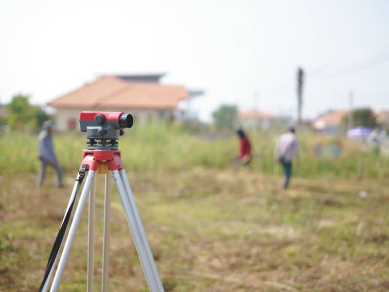
Phase 2: The Field Visit (What Happens on Your Property)
During the field visit, a survey crew visits your property with specialized equipment to take measurements. They locate existing boundary markers, measure distances and angles, and record the physical features of the land. This visit typically lasts a few hours for a standard residential lot. You are not required to be present.
This is the part most people picture when they think of a land survey. A crew of one to three people arrives at your property carrying equipment such as a total station, GPS receivers, and measuring rods.
Here is what they do during the field visit:
1. Locate existing markers. The crew searches for any iron pins, pipes, or concrete monuments that mark your property corners. These may be buried just below the surface or hidden by vegetation. Finding them is a key part of verifying your boundary.
2. Measure the property. Using their equipment, the crew measures distances and angles between points on your property. Modern GPS equipment can pinpoint locations to within centimeters, which is far more precise than older methods.
3. Document what they find. The crew records everything they observe, including fences, structures, driveways, utility lines, and natural features like trees or streams. All of this goes into their data set for the office phase.
4. Set new markers if needed. If corner markers are missing or were never placed, the surveyor may set new monuments at the correct locations. These are legal boundary markers and should never be moved.
You do not have to be home during the field visit. However, if you are available, it can be helpful to point out any physical features you are aware of, such as where you believe a corner marker is located.
Phase 3: Office Work and Final Deliverables
After the field visit, the surveyor returns to the office to process the data, draft the survey map, and prepare the legal documents. This phase typically takes several days to two weeks. When complete, you receive a signed and sealed survey plat, which is a legal document showing your property boundaries and any relevant features.
Back in the office, the surveyor takes the field data and turns it into your final document. This involves:
- Calculating all measurements and checking them against the deed research
- Drafting the survey plat, which is the official map of your property
- Noting any encroachments, easements, or discrepancies found during the process
- Signing and sealing the document with the surveyor’s professional license stamp
The survey plat is a legal document. You can use it to resolve disputes, apply for permits, close on a real estate transaction, or record with your county.
What You Receive at the End
Most surveys result in at least one of the following:
- A signed and sealed survey plat showing your boundary lines, corners, and dimensions
- A written legal description of your property
- Physical monuments set at your corners during the field visit
- A digital file you can share with your attorney, lender, or builder
Keep your survey on file. Future projects will reference it, and having it on hand saves time and money down the road.
How Long Does the Whole Process Take?
Most standard residential surveys are completed within one to three weeks from the time you place your order. Larger properties, properties with complicated records, or surveys requiring extra research may take four to six weeks.
Factors that can extend the timeline include:
- Incomplete or conflicting deed records
- Heavy vegetation or difficult terrain that slows down fieldwork
- A high volume of orders with the surveying firm
- Additional government review required for certain survey types
If you have a closing date or permit deadline, tell your surveyor right away. Most firms can discuss their current timeline before you commit.
Frequently Asked Questions
Do I need to be home when the surveyor comes?
No. Surveyors do not need access to the interior of your home. They only need access to your land. If your property has a locked gate, let the surveyor know in advance so arrangements can be made.
Will the surveyor tell me if there is a problem with my property lines?
Yes. If the surveyor finds an encroachment, overlap, or discrepancy, it will be noted on your survey plat and explained to you. It is then up to you and your attorney to decide how to address it.
Can I use a survey from 10 years ago?
It depends on your situation. An older survey may still be valid if nothing has changed. However, lenders, title companies, and permit offices often require a recent survey. Check with the party requesting it to confirm what they will accept.
What should I do after I receive my survey?
Store a copy in a safe place with your other property documents. Share it with your lender, attorney, or contractor as needed. If your survey reveals an issue, contact your surveyor or a real estate attorney to discuss your options.